Ukraine War Update: Zaporizhzhia Map Changes
🤖
This summary has been produced automatically by an AI Large Language Model (LLM) without any human intervention. Whilst every effort has been made to prompt the LLM to produce accurate output, there may be inconsistencies, inaccuracies or hallucinations!
Table of Contents 📖
| Topic ID | Topic Title | Timestamp |
|---|
"So anyway, that's just me going off on one concerning mapping there. But I really like these Poulet-Vollon maps."
Hello Team!
Jonathan introduces the video as a quick update focusing on the frontline changes in the southern Donetsk and Zaporizhzhia regions over the last month. He will be using relief maps from a French mapper called Poulet-Velon to illustrate the changes between 30th November and now.
Return to top⤴️
Vuhledar/Vuhlehirsk area
- The thick red line on the map shows Russia's current frontline, the blue line is Ukraine's frontline
- Over the last month:
- Ukraine has advanced near Novomykhailivka and in the corner area, with a tiny loss
- Russia advanced near Pavlivka (which they briefly controlled before losing again - it's a "grey zone")
- Russia took control of Mykilske and some area around Solodke
- Russia lost a bit of ground north and east of Novomykolaivka but are pushing towards it
- Jonathan likes the relief shown on these maps, you can see the lower ground around water features rising above
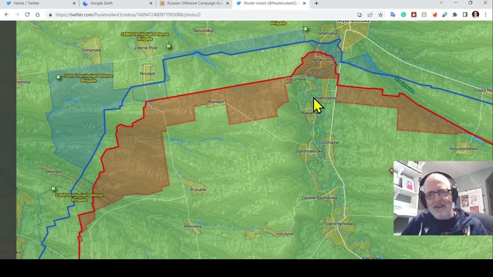
Neskuchne area
- Moving west to Neskuchne and Vremivka which have seen recent fighting
- Over the last month:
- Russia made gains in Neskuchne itself and the surrounding area like Rivnopil
- Ukraine also advanced, suggesting this was a larger grey zone before with both sides closing in
- Ukraine retreated around Novopil and south of Vremivka towards Neskuchne
- Jonathan previously reported on a battle here where Russia advanced but lost a lot of equipment, which was caught on live camera
- Modern warfare allows live feeds to command centers for reactive decision making, and sometimes this footage makes it to social media giving the public a view too
Zaporizhzhia frontline
- Further west near Hulyaipole, Russia claimed to have taken territory from Ukraine today but this is unconfirmed. The ISW suggests Russia may be exaggerating their gains.
- Jonathan hasn't reported much on Zaporizhzhia over the last month but there has been some activity:
- Ukraine advanced and Russia retreated around Myrne and Zakhidne
- Russia had success around Kostyantynivka and some smaller settlements near Hulyaipole which is concerning as it's a major town
- West of Orikhiv there have been Russian advances around Nesteryanka
- Jonathan wonders if he previously reported on a mechanized attack by Russia or Chechens/Georgians fighting for Ukraine in this area
- When large amounts of territory change hands, it's important to consider if it's actually meaningful control or just open farmland
Mapping and control of territory
- Early in the war, some mappers showed Russia controlling vast areas but in reality they only controlled key roads with the land in between not secured
- This was the case with the infamous 40 mile Russian convoy which got picked off by Ukrainians concealed in forests who took advantage of the lack of Russian control of the surrounding area
- Jonathan goes on a tangent about mapping but reiterates that he really likes these Poulet-Vollon maps and may look into whether the source regularly updates them
Wrap up
Jonathan concludes by saying he wanted to show the month-on-month changes in the Zaporizhzhia area. He will try to do a proper extra update video soon and tells viewers to keep an eye out for it.
Return to top⤴️
🤖❓ AI Debrief (post task) - anything the AI didn't understand
🤖💭 AI Plan (pre task) - the AI's step by step thought process
Steps:
Watch the video and read through the transcript to understand the content and key points
Identify the main topics covered in the video based on the transcript
Write a concise summary for each topic, ensuring key information and insights from Jonathan are included
Use the provided XML structure to format the summary
Review the summary to check it is clear, captures the main points and is free of errors